Bush bashing for cairns

 Flag Hill

Sounds like bowling for dollars. We’ve been clearing drainage ditches along the lighthouse road and my body only lets me do that every other day, so we explore or relax on the off days.

We’ve (mostly Tim) cleared the major tracks and have looked at old maps and surveys and found other places to explore. One map shows two cairns on a hill near the house. I had read somewhere that in the 1800’s when they surveyed this area, they placed two survey markers (maybe cairns?). The cairn on Barn Hill on the southwestern bluff is easy to find and has a track to it. I’m not sure when these were placed but the Parks Ranger confirmed they were there and they would mark the north.

Back in the fold

Before we started, we wrangled a baby wallaby out of the inner compound.  It was trapped inside while its mother was still outside and they would hang out on either side of the fence near one another.  The mother didn’t seem too concerned.  We had to get her near one of the gates to lure him out.  Once reunited, he tried to get back into the pouch, or at least stuck his head there.

So off we went, bush bashing. We worked our way through tussock grass to the trees on top of the hill. We passed a tree with what looked like funnel spider webs to me. I wonder if other spiders spin funnels? Funnel spider? face Flag Hill southern cairn

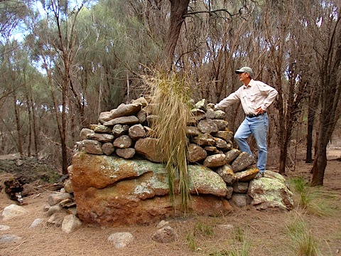
The first cairn was easy to find.

Then we walked along the plateau and saw other perspectives of Erith Island.  

A new perspictive of Erith Island

Aboriginal cave

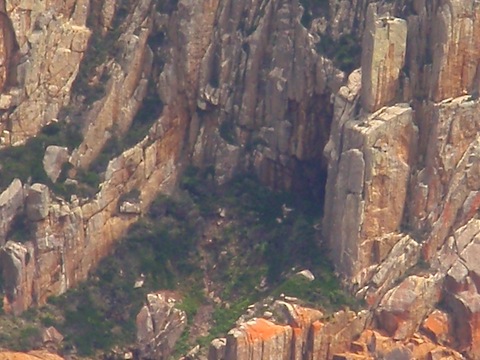
We think we could see the entrance to the cave on the northern end of the island.  An archeaologist, Rys-Jones, found evidence of aborigines living there 7,000 – 10,000 years ago.

There used to be a mountain range connecting Wilson’s promontory in Victoria, northwest of the Kent Group of Islands, and northern Tasmanania, to the southeast.  The range included these islands and Flinders Island to the southeast.  These mountains were occupied by aborigines until the sea rose and isolated it from both the mainland of Australia and Tasmania.  Now they are islands and the water is about 50 meters deep.  The findings in the cave and elsewhere, suggests the land bridge closed thousands of years later than originally thought.

Lunch lichen

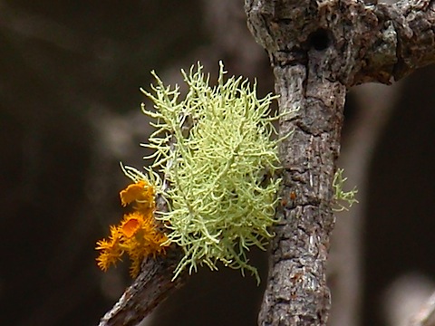
Lichen growing on a tree near our lunch spot.Gnarly old man rock

Gnarly old man rock.

We continued north, over two saddles and found the second cairn.   P1260174.JPG  Pulpit rock P1260206.JPG

The bonus is that we think we also got a glimpse of the elusive Pulpit Rock.  We missed that during our previous bush bash to Pegleg Cove.

We ran into the three stooges on our way home.Apres cairns A good time was had by all.

American lady on Deal Island

That’s me. We use the VHF radio to communicate with local boaters. We provide weather information and sometimes they just want to check in with us. Then when they leave, they bid farewell. Yesterday, a group tried to hail me on the radio by calling, “American Lady on Deal Island, American Lady on Deal Island”. I must have been away from the radio because other boaters told me about it. Then I was referred to last night as the siren in Bass Strait because the majority of people on the radio are male. People come in lashed to their masts! I don’t get it. We’ve both been referred to as the crazy Americans on Deal Island. They’ve got that right.

P1240119.JPG

Since there isn’t a lot going on, we and all boaters, are big eavesdroppers. Boats hail one another, or us, on Channel 16 and then switch to another frequency to chat. Yesterday, we heard a boat we knew, arrange to offload fuel from a large ship (I guess the wind wasn’t in their favor and they ended up motoring more than planned). We get weather reports by radio when the internet isn’t working. We can hear boats check in with the volunteer Coast Guard service. They report their positions and ETA’s and are actually tracked. One radio man we enjoy listening to is at Tamar Coast Guard. Everyone in Bass Strait knows Brynn, the Welsh radio man. He broadcasts the weather four times a day and takes position reports and passes on messages. He is a legend, I think in his 80’s and a comfort to hear even when the weather news is bad.

P1250122.JPG

P1250123.JPG

Yesterday we enjoyed a dinner at the BBQ down by the pier with good company. Boats are passing through on their way to a wooden boat festival in Hobart. There were beautiful boats and fun people. We’ ve exchanged contact information with many. The group yesterday included a former caretaker from the 1990’s. He never thought he would make it back here and delighted in the island and the many improvements in the compound and quarters. I wonder if we will ever get the chance to come back here.

Ditch Digging in Paradise

PC220059.JPG

We both agree that one project we want to compete while we are here is clearing the drains along the lighthouse track. This track is about 2.5 kms long and climbs 305 m. There are several steep sections and when it rains, as it has over the past few days, we get an inch at a time, water comes cascading down the hill and the track. Since the lighthouse was built, more than 150 years ago, there have been various drainage schemes installed. The most basic is a ditch along the side of the road, with various places for water to run off the road into the ditch. That’s where we worked yesterday, clearing sheoke needles from the drain and digging deeper where it overflows. The road is a macadam surface and there are culverts across it, some concrete lined. There are culverts under the road made of steel, cement and most recently PVC. Our mission if successful, will be to clear all those drains, dig deep when needed and do our bit to prevent the road from eroding further.

P1230125.JPG

I would like to say I was there merely as the official photographer but I wasn’t. We raked and carried and dug. I have the aching back to show for it. We were able to clear two sections of switchbacks and build up the ditch in a couple of areas.

At one point, Tim cleared an area and revealed a huge jack jumper ant colony. I steered clear of that and we avoided getting bitten.

One day we have to go up the track when it’s raining to see the weak spots. But I had a hard enough time going outside today in the rain to get our drinking water from the tank.

P1170124.JPG

We have had several boats and visitors ashore despite the rain and wind. The kayakers are still here but may get a weather window tomorrow to head southeast to Flinders Island. I can’t even convey what it must be like to kayak across the Bass Strait. Big seas, wind and currents. One man’s kayak was sinking on the way from Hogan Island to here because water was getting in via a through hull for a rudder cable and he wasn’t sure it would make Erith Island. He said he can now tick “Terror” off the emotions experienced during the trip.

Cleaning day in paradise

Even though we live in paradise, we still have mundane chores to do. They are certainly easier when you can look out the window and enjoy a beautiful view. Yesterday, I was all over the island but today I hunkered down at home. Tim was off clearing Squally Track and I had some cleaning to do. The question I would like answered is, can spiders and bugs crawl back out of the vacuum??? There must be a security door at least in Australia because I hear a lot of people talk about vacuuming up those huntsmen spiders. I didn’t have anything nearly as ambitious as that but almost caught a lizard by accident in the sun porch.

Another gorgeous day

I spent time rereading more history about the group of islands and the people that explored or visited here. This group of islands was a land bridge between Wilson’s promontory in Victoria to the northwest and Flinders Island to the southeast. It flooded somewhere around 12,000 years ago but there is evidence of people living in a cave on Erith Island, 7,000 years ago. 7,000 years ago!

The Beagle (of Charles Darwin fame but without him on board) nearly floundered in the cove because of the current and williwaws. Captain Bligh, of Mutiny on the Bounty fame, was given two ships and sailed back to explore Tasmania after he was cast adrift. reading Matthew Flinders and George Bass proved there was a strait between Tasmania and Australia and named it after Bass. Flinders named the Kent Group after a colleague, William Kent, and then the islands seem to have been named after towns in Kent, England: Erith, Dover and Deal.

Erith Island has been visited by historians, naturalists, artists and writers for more than 40 years and their connection to the island helped preserve the original caretaker residence, which houses a museum they established. Every one who spends time here is moved by the experience. I know I am.